[Ilmestynyt alun perin Facebookissa.]
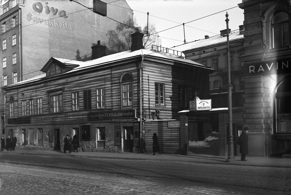
Ennen kuin Kevan avaruusalus laskeutui vuonna 2005 Unioninkatu 43:n kohdalle, paikalla oli ollut tyhjää yli 40 vuotta. Valtion omistama tontti oli ollut lähes rakentamaton niin pitkään, että viereisten kerrostalojen päätyseinistä oli tullut vakituisia mainospaikkoja. Naapuritaloista se kuuluisampi on Pitkänsillan kupeessa oleva suuri Unioninkatu 45, “Pikku-Naantali”.
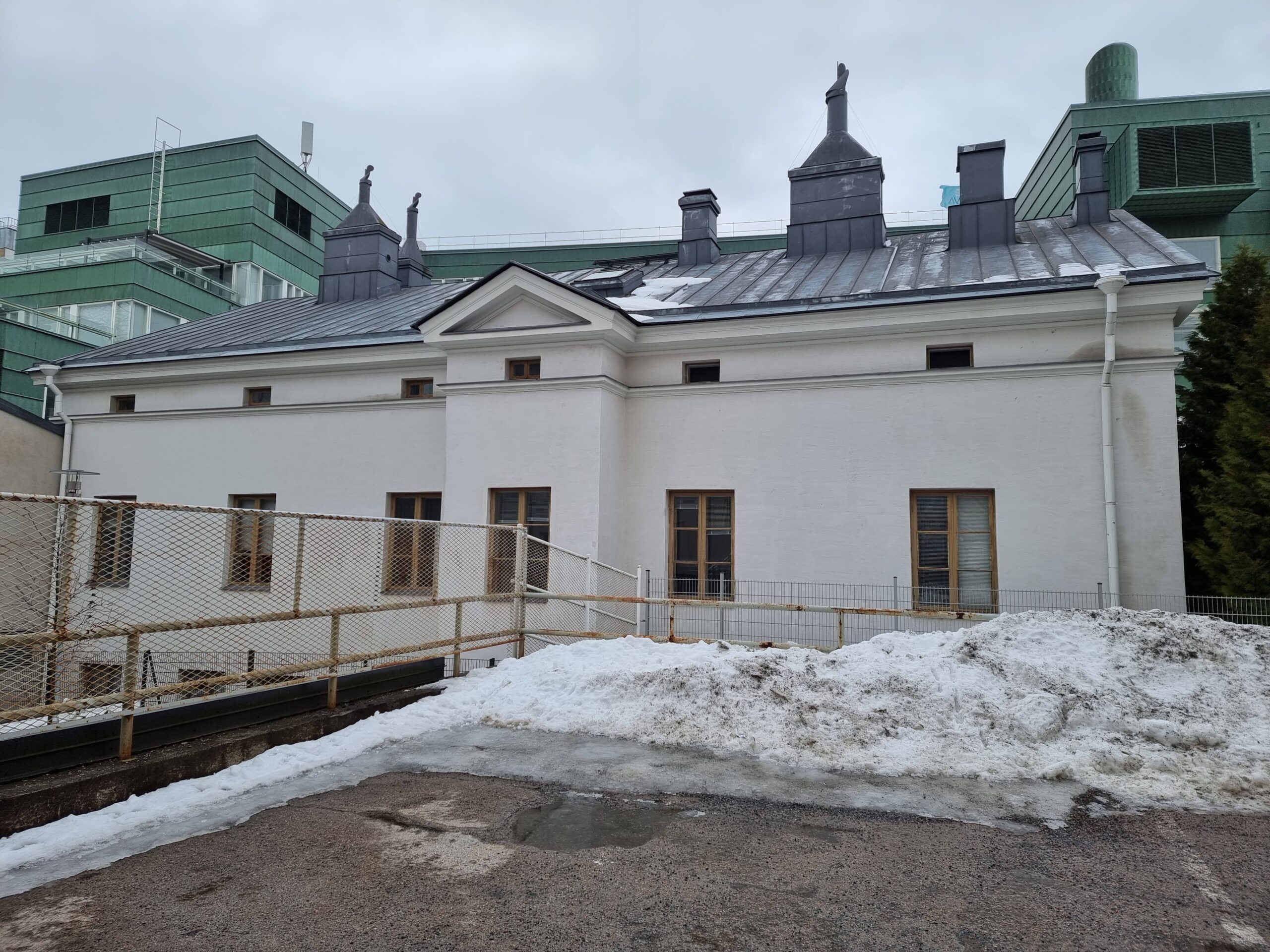
Yksi rakennus tontilla oli. Sen takaosassa, rinteellä, oli seissyt kaksikerroksinen kivirakennus jo vuodesta 1869. On talo siellä vieläkin, mutta kadulle sitä ei näe, koska Keva on nielaissut kaiken. Toisen kerroksen takalisto pilkahtaa ylempää mäeltä, Siltavuorenpenger-kadun mutkasta, Kruununhaan yläasteen pihamaalta. Talo oli ollut useamman kerran purku-uhan alla, mutta säästyi joka kerta, ja viettää nyt siis eläkepäiviään, kirjaimellisesti.
Vielä 1820-luvulla, kun talon rakennuttaja, kofferdikapten (kauppalaivaston merikapteeni) Johan Edvard Lönnberg, syntyi kalastajaperheen viidentenä, nuorimmaisena, Espoon Pentalan saaressa, tämä Hevosen kortteli oli kaavoittamatonta aluetta. Siltavuorenpenkereen kalliot olivat toimineet kaupungin hirttopaikkana, joten ei ihme, että Helsingin hiljalleen kasvava porvaristo ei ollut järin innostunut asettautumaan niille sijoille. Paikka oli sinänsä ihanteellinen kaupungin rajalla, ainakin nykymittapuun mukaan. Korkealta kalliolta näki Kaisaniemen puistoon, ranta pesupaikkoineen oli lähellä ja Sörnäisten tehdasalue pohjoisessa oli vasta aluillaan. Lähivedet olivat tosin taatusti likaisia jo silloin, mutta sellaista elämä nyt vaan oli.
Tonttikaupat tehtiin 1850-luvun lopulla. Tontin vidd i qadrat oli 6370 syltä ja arvo 5000 ruplaa. Syli oli kolme kyynäränmittaa, noin kaksi metriä. Neliöitä siis vajaat 3600. Rupla oli 4 markkaa, joten nykyrahassa Lönnbergin tontin arvo oli noin 6000 euroa. Tontti oli suuri, mutta sille piti mahtua paljon muutakin kuin itse talo: kaivo, kasvimaa ja eläinsuoja olivat ihan minimi. Vuonna 2024 samankokoisia ja -hintaisia omakotitontteja kyllä löytyy Suomesta, mutta enimmäkseen linjan Vaasa-Kuopio pohjoispuolelta.
Ison kivitalon rakentaminen Suomen pääkaupunkiin ei kuulosta halvalta huvilta. Merikapteenin ammatti oli kuitenkin varsin rahakas. Kun hankki koulutuksen, sillä sai porvarioikeuden tukku- tai vähittäiskauppiaana. Jokaisesta laivan lastauksesta ja purkamisesta maksettiin varsinaisen kapteeninpalkan päälle ylimääräistä, jokainen satamassa poikkeaminen merkitsi tiettyä lisäsummaa ja jokaisesta rahdista päällikkö sai tietyn prosentin. Kirjallisuudesta löytyy vertailutieto, että merikoulujen johtajien vuosipalkka oli 4000 markkaa (~25000 euroa), mutta ansioissa he jäivät jälkeen laivapäällystöstä juurikin näistä erinäisistä lisistä johtuen.
Kalastajaperheen pojasta merikapteeniksi ei ollut mikään helppo luokkanousu, vaikka sinänsä loogiselta kuulostaakin. Johan oli 16-vuotias, kun isä kuoli. Viimeistään nyt hänen oli pakko miettiä tulevaisuutta. Hän tietysti tunsi jo meren, ainakin lähialueet. Helsingin torilla oli käyty kesäisin myymässä kalaa, ja Pentalasta pääsi myös talvisin jäätietä pitkin pääkaupunkiin. Ensimmäinen varsinainen uutisia julkaissut sanomalehti, Helsingfors Tidningar, oli yhtä vanha kuin Johan, ja kauppalaivoista kirjoiteltiin alusta asti. Nouseva ala, mahdollisuus nähdä maailmaa. Joten – miksipä ei? Jos ymmärsi jo entuudestaan veneilyn ja säiden päälle eikä ällin ja/tai kunnianhimon puute ollut esteenä, esimerkkien voima vei eteenpäin.
Vuonna 1846, 17-vuotiaana, Johan pestautui laivakokiksi Orienten-purjelaivaan, joka vei sahatavaraa Espanjaan ja toi suolaa. Perusreitti kulki Tanskan salmen, Englannin kanaalin, Lissabonin, Cadizin ja Gibraltarin salmen kautta Malagaan. Godwin Sands lähellä Doveria oli otettava tarkasti. Kymmenen mailin pituinen hiekkatörmä muutti muotoaan jatkuvasti merivirtojen mukana. Nousuveden aikana törmää ei näkynyt, vasta laskuvesi paljasti missä se oli. Vuonna 1848 Orienten karahtikin kiinni. Siinä vaiheessa Johan oli kuitenkin ehtinyt vaihtaa pestiä jo kahdesti.
Orienten vaihtui kuunariin Lovisa Carolina vuonna 1847 ja kokin homma jungmanniksi, laivapojaksi. Johan oli nyt siis harjoittelija ja matkalla kohti asteikolla vastuullisempia päällystöammatteja. Puutavaraa vietiin edelleen Espanjaan, mutta myös Riiassa ja Travemündessä/Lyypekissä käytiin. Suolaa tuotiin Espanjan lisäksi Hullista. Yhdellä näistä paluumatkoista, joulukuun viidentenä yöllä, Lovisa Carolina ajoi karille Pohjanmerellä Norjan edustalla, parin kilometrin päässä Mandalista. Laiva tuhoutui, mutta lasti ja miehistö pelastuivat.
Kuunarista prikiin ja laivapojasta “kevytmatruusiksi”, puolimatruusiksi eli aloittelevaksi kansimieheksi. Vuonna 1848 Hoppet-priki kuulosti lupaavalta, mutta toisin kävi. Lokakuun lopussa Kattegatissa myrskysi ja useampi laiva teki haaksirikon, niiden mukana Hoppet, joka oli matkalla Amsterdamiin. Tälläkin kertaa miehistö pelastui, laiva ei.
Puolimatruusin pestissä kului vielä seuraavakin vuosi, nyt purjelaivassa Dygden. Välimerelle ja takaisin, Englantiin ja takaisin.
Vuodet 1850-1853 Johan Lönnberg onkin sitten jo styrman, yksi kapteenin lähimmistä miehistä, jotka hoitivat navigoinnin, kirjoittivat laivan lokikirjaa yms. Ensin kuunari Sophia, sitten ensimmäinen monivuotinen pesti parkki Africassa, joka kuulosti eksoottiselta, mutta kauimmainen satama oli yhä vain Espanjassa. Viimeinen oli Phoenix. Styrmannin paikan saadakseen oli suoritettava vastaavat opinnot, ja Johan hankki ne Helsingfors Navigations Skolanissa Ullanlinnassa.
1852 Suomessa oli paha koleraepidemia, mutta Johanilla oli onnea, koska oli enimmäkseen merillä. Seuraava vastoinkäyminen oli kuitenkin jo ovella: Krimin sota 1853-1856. Suomen laivat olivat brittiläisten tulilinjalla, koska suurin osa Venäjän lipun alla purjehtivasta kauppalaivastosta oli Suomessa. Liikenne seisahtui, aluksia tuhoutui runsaasti. Johan käytti pakollisen luppoajan viisaasti ja luultavasti myös ainoalla mahdollisella tavalla: perusti perheen ja kouluttautui lisää. Avioliitto muurarikisällin tyttären Sofia Forsbergin kanssa solmittiin 15.11.1855. Samana syksynä alkoivat talven kestävät kapteeniopinnot merikoulussa.
Tunteja oli 2-6 tuntia päivässä ja oppiaineita kunnioitettava määrä: räknäyskonsti, geometria, trigonometria, tähtienoppi, taklinki ja merimiehisyys, seililaiwain käytteleminen, tieto lastinpanosta ja sowittamisesta sekä ensimmäiset perustukset saksan, franskan ja engelskan kielissä. Koulutus oli yksinomaan teoreettista, koska oletettiin, että käytännön taidot omaksutaan aluksilla. Oppilasmäärissä oli paljon vuosittaista vaihtelua. Johan Lönnbergin lisäksi lukuvuonna 1855-1856 kapteenin opinnot suoritti ainostaan yksi toinen henkilö: C. F. Lundgren. Kondiittorin poika ja selvästi Johania vanhempi. Koulussa hän sai parempia arvosanoja kuin Johan, mutta mitä mahtoi sen jälkeen tapahtua? Lundgren katoaa. Ehkä käytännön elämä laivalla ei sittenkään ollut häntä varten.
Kuunari Marialla Johan toimi jo komentajana. Vuosi oli 1857. Maria purjehti Riian, Viipurin ja Helsingin väliä, ruumassa rautaa ja kappaletavaraa. Ensimmäinen höyryalus Johanin uralla oli siipiratasalus Sibbo vuonna 1858. Sitä seurasivat Murtaja, Nicolai ja lopulta Alexander, Johanin pitkäaikaisin (ja viimeinen) pesti vuosina 1868-75.
Mitä laivoilla sitten kuljetettiin? Tilastollinen vuosikirja 1866-1870 listaa tärkeimpiä tuotteita, joiden määrä kasvoi tai pieneni suhteessa edelliseen tilastokauteen.
Enemmän tuotiin mm. arrakkia, konjakkia ja rommia; köysiä ja nuoria; pellavaa; petroleumia; pumpulia; raakaa sokeria; rautaa; ruisjauhoja; vehnäjauhoja. Vähemmän mm. kankirautaa; kynttilöitä; rukiita; sampanjaa ja mousseeravia viinejä; siirappia; suolattua kalaa; toppusokeria. Enemmän vietiin mm. battens (=lautatavaraa); eläimiä; hirsiä; kaloja; kankirautaa; kattopäreitä; kauroja; klasitavaroita; lankkuja; luita ja luujauhoja; parruja; steariinikynttilöitä; terästä; vinttikankia; voita. Vähemmän mm. höyheniä ja untuvia; kuparia; ohria; pellavaa ja hamppua; rukiita; talia; tervaa.
Suomessa oli nälänhätä 1866-1868 ja se näkyy tuontiviljan määrässä, kenties myös vahvan alkoholin. Jonkinlaisesta jalostusasteen noususta kertoo kynttilöiden ja kankiraudan suunnan vaihtuminen. Terva vaihtui puutavaraan.
Purjelaivojen valtakausi kesti Suomessa pitkään, huomattavasti pidempään kuin muissa merenkulkumaissa. Höyrylaivoissakin oli vielä pitkään purjeet vakiovarustuksena, varmuuden vuoksi, koska uuteen tekniikkaan ei voinut aina luottaa. Höyrylaivoilla oli kuitenkin selkeitä etuja: tasainen, varma ja nopea kulku, ei juurikaan haaksirikkoja, paljon pidempi kausi liikennöidä. Matkojen nopeutuminen tarkoitti toisaalta kiireen lisääntymistä satamassa, sillä purku- ja lastausvaiheen piti sujua rivakammin.
Samana vuonna kun Johanista tulee kapteeni, Sofia synnyttää ensimmäisen lapsensa. Alkavat Lönnbergien ruuhkavuodet. Perhe asuu muutaman vuoden parissa eri osoitteessa Kampissa ja Punavuoressa ennen kuin 1850-luvun lopussa ostavat tontin osoitteessa Unioninkatu 2, Kaisaniemen puiston sisäänkäyntiä vastapäätä. Portti on samalla paikalla yhä, mutta nyt vain puiston henkilökunnan käytössä. Tontilla oli kadun varressa kaksikerroksinen talo, jossa alakerta oli kiveä, yläkerta puuta. Rakennuksessa oli myös liiketiloja. Vuokralaisia oli aluksi neljä: vahtimestari Silander, kauppias Oftschennikoff, extra kanslist Winter ja valokuvaaja Liebert. Liebertillä oli oma ateljee, joten varmasti myös Lönnbergit asettuivat silloin tällöin kameran eteen. Mitään todistetta tästä ei kuitenkaan valitettavasti ole. Merikapteenista ja hänen vaimostaan en ole löytänyt yhtään valokuvaa.
Talon sijainti tunnettiin nimellä kapten Lönnbergs gård ja vuokralla olleet yritykset käyttivät tätä lehti-ilmoittelussaan. Valokuva-ateljeen lisäksi osoitteessa toimi vuosien varrella mm. leipomo ja olut- ja etikkakauppa, joka myi baijerilaisia ja ruotsalaisia oluita. Talo purettiin 1940-luvun alussa.
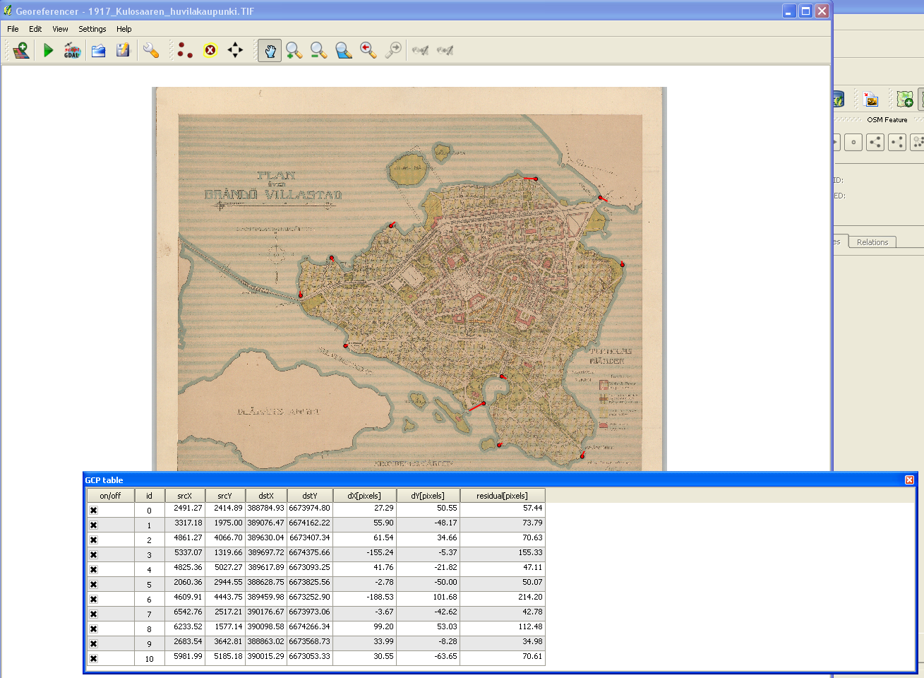
Jos ihmettelette kuten minä tein luvattoman pitkään, niin Unioninkatu 2 on sama tontti, jonka takaosaan Lönnberg rakennutti kivitalon 1860-luvun lopussa, Unioninkatu 43. Kadun numerointi vain vaihtui 1800-luvun loppupuolella alkamaan etelästä, entisen pohjoisen sijaan. Hupskeikkaa.
Johan Lönnberg oli siis paitsi merikapteeni myös aktiivisesti mukana kiinteistöbisneksessä. Suurimmillaan vuokralaisten määrä oli 1870-luvun vaihteessa, jolloin Lönnbergin oman, tuossa vaiheessa jo 6-lapsisen perheen, vaimon siskon ja kolmen palkollisen lisäksi tontilla asui yhteensä lähemmäs 30 henkeä. Tarina ei kerro (tai en ole osannut tulkita), kuinka moni asui kadunvarren talossa, kuinka moni uudessa kivitalossa. Merikapteenin oli liki mahdotonta hoitaa aluksilta käsin mitään kuivan maan asioita, joten todennäköisesti sekä kiinteistöjen hoitovastuu että vuokrankanto lankesivat ensijaisesti Sofia-vaimolle. Varmaa tämä ei ole. Kuten historiassa on tapana käydä, naisten elämästä ei useinkaan jää mitään arkistojälkiä.
1870-luvulle tultaessa kauppamerenkulun huippuvuodet alkoivat olla takana. Vaikutti siltä, että meikäläiset höyrylaivat ohitettiin vasemmalta ja oikealta. Ulkomaiset höyryalukset olivat isompia ja niitä oli enemmän. Suomen kunniakas purjehdusperinne, tunnetut veneveistämöt ja entinen mahtiasema Venäjän lippulaivastona jarruttivat aluskannan uudistumista. Lisäksi maailmankaupassa alkoi pitkä sarja lamavuosia, josta on syytetty eritoten Suezin kanavan valmistumista vuonna 1869, sillä se lyhensi merireittejä. Äkkiä merillä oli tonniston liikatarjontaa.
Kofferdikaptenen Johan Edvard Lönnberg kuoli 11.2.1882, 54-vuotiaana. Kuolinsyy oli hjertlidande eli luultavasti perinteinen sydän- ja verisuonitauti. Kuolema oli vieraillut perheessä jo kahdesti aiemmin, mikä ei 1800-luvulla ollut tietenkään millään lailla tavatonta. Elintaso oli merikapteenin perheessä kuitenkin sen verran korkea, ettei yksikään lapsi menehtynyt ensimmäisten elinvuosien aikana toisin kuin Johanin lapsuudenkodissa Pentalassa. Luokkanousu ei sen sijaan pidentänyt merikapteenin omaa elämää, luultavasti päinvastoin: Johanin isä, kalastaja Carl Lönnberg, oli kuollut saman ikäisenä.

Esikoispoika Frans Bernhard kuoli lavantautiin 21-vuotiaana vuonna 1878, viisi vuotta ennen isäänsä. Samana vuonna Helsingin keskustan vesijohtoverkosto alkoi olla valmis, mutta yleinen viemäri oli vasta suunnitelman asteella. Jätteet ja jätevedet imeytyivät maahan ja sitä myötä kaivoihin. Vesi voi olla vanhin voitehista, mutta se osaa myös olla salakavala tappaja. Frans Bernhard opiskeli ensimmäistä vuotta Suomen polyteknillisessä koulussa, joka oli vastikään muuttanut Hietalahteen. Lavantautiin sairastuttiin useimmiten kesäkuukausina, ja tauti saattoi kestää pahimmillaan kolmekin kuukautta. Lönnbergin tontilla oli oma kaivo, mutta ei ole vaikea kuvitella opiskelijanuorten hörpänneen kesän mittaan vettä jostakin kaupungin paristakymmenestä yleisestä kaivosta, joissa veden laatu oli mitä oli. Niiden ensisijainen tarkoitus oli tarjota sammutusvettä tulipalon sattuessa. Turun palo oli tuoreessa muistissa. Kuolleisuus oli lavantaudissa 25%. Kohtalotovereihin kuului myöhemmin mm. Elias Lönnrot.
Wilhelmina Cecilian kuolinaika ja -syy jäivät selvittämättä, koska kuolema osui erittäin runsaan nälkävuosien kuolleisuuden vuosiin 1866–1868. Joka tapauksessa perheen ensimmäinen tytär eli vain noin kymmenvuotiaaksi.
Isän poismenon jälkeen seuraavana oli vuorossa fröken Anna Sofia. Hänet vei tuberkuloosi 35 vuoden iässä vuonna 1894. Seuraavana vuonna kuoli äiti-Sofia. Hän eli 65-vuotiaaksi.
Elin Ulrika ja Karl Johan, perheen toinen poika, perivät isänsä heikon kohdan.
Sairaanhoitaja Elin kuoli sydänvaivoihin 51-vuotiaana vuonna 1915 Vihdissä. Esimerkki siitä, mitä testamentti saattoi tarkoittaa: Elinin kummitäti, viipurilainen kätilö Kristina Kärkkänen, testamenttasi kummilapsilleen rahaa. Yksi saajista oli Elin. Rahasumma oli 2000 markkaa, reilut 10000 nykyeuroa, mikä oli huomattava summa.
44-vuotias Karl Johan (muotokuva Geni.com-sivustolla) menehtyi Kyminsuussa vuonna 1907 ankaraan sydäntautiin eli ilmeisesti sydänkohtaukseen. Karl Johanilla oli takanaan menestyksekäs ura Haminan kadettikoulussa ja sen lakkauttamisen jälkeen Kymin lastausyhtiössä. Hän harrasti purjehtimista, viulunsoittoa ja kirjoittamista, ja ansiolistalla oli myös kunnallisia luottamustehtäviä. Lönnbergien historia höyrylaivoilla sai surullisen lisän: Karl Johanin ruumis kuljetettiin Kyminsuusta rautatieasemalle Halla II -nimisellä lastausyhtiön höyrylaivalla. Hautaus tapahtui Hietaniemen hautausmaalla Helsingissä.
Kieltenopettaja Agnes Wilhelmina eli perheestä pisimpään. Vuodesta 1918 lähtien kuolemaansa asti vuonna 1935 Agnes asui Kemiössä Dahlby Mellangård -nimisellä tilalla, jonka oli hankkinut yhdessä Frida Wilhelmina Gräsbeckin kanssa. Frida oli kotoisin Kuopiosta ja toimi myöhemmin mm. kauppiaana Vihdissä. Agnes vaikutti perineen isänsä ahkeruusgeenin. Ennen Helsingistä Kemiöön muuttoa hän ehti olla monessa mukana kuten osakkaana siirtomaatavaraliikkeessä, opettajana valmistavassa koulussa (polku oppikouluun) ja järjestöaktiivina Nuorten naisten kristillisessä yhdistyksessä. Agnes kuoli syöpään 68-vuotiaana.
Kaikki Lönnbergin perheen lapset syntyivät ennen Unioninkadun kivitalon valmistumista, viimeisenä Alma Emilia vuonna 1868. Suosittu uusi ammatti nuoren naisten keskuudessa 1800-luvun lopulla oli voimistelunopettaja. Alma pääsi oppilaaksi Aspin pariskunnan voimisteluinstituuttiin ja onnekkaasti edelleen ulkomaille asti. Vuosina 1893-1895 hän suoritti Ruotsissa Kungl. Gymnastiska Centralinstitutetin ja harjoitti sen jälkeen Helsingissä lääkintävoimistelijan eli nykysuomen mukaan fyssarin tointa. Syksyllä 1914 Alma muutti Ahvenanmaalle ja ryhtyi ystävänsä kanssa harjoittamaan maanviljelystä. Viimeiset elinvuotensa hän vietti Kemiössä isosisko Agneksen luona. Samoin kuin Anna Sofia, Almakin kuoli tuberkuloosiin, 56-vuotiaana vuonna 1924.

1800-luvun loppupuolen suomalainen yhteiskunta ei välttämättä ollut naisille mikään superankea takapajula. Yli 25-vuotiaat naimattomat naiset olivat täysivaltaisia eli oikeustoimikelpoisia vuoden 1864 jälkeen, yhtäläinen perintöoikeus tuli 1878, elinkeinovapaus 1879. Uudistuksia, jotka oli kuin tehty Lönnbergin kaikille neljälle aikuisikään asti eläneelle, naimattomalle ja lapsettomalle tyttärelle. Kaikki kouluttautuivat ja osoittivat yritteliäisyyttä. Isän ja äidin jättämän perinnön suuruutta on mahdoton hahmottaa tässä ja nyt, mutta merkityksetön se ei tytärten elämässä taatusti ollut. Tärkein (ja ainoa) oli Unioninkatu 43 taloineen. Isän perukirjassa sen arvoksi asetettiin 90 000 markkaa, joka on nykyeuroissa noin puoli miljoonaa euroa. Äidin perukirjassa arvoa oli nostettu 100 000 markkaan. Nykymuotoista perintöveroa ei tuolloin vielä kannettu.
Perukirjojen avulla voi maalata mielikuvaa siitä, miltä Lönnbergeillä näytti. Kamera kiertää. Vanhempien makuuhuoneessa, sängyn viereisellä pikkupöydällä, tikittää merikapteenin hopeinen taskukello. Ikkunan ääressä on matala kaappi, joka toimii pesupaikkana. Seinustalla on lipasto vuodevaatteille ja vaatekaappi, kokovartalopeili ja chiffonjé, pystymallinen kirjoituspöytä, jonka alaosassa on laatikosto. Keittiön pöydällä lepäävät piian juuri puhdistamat pöytähopeat, nurkassa on silitysuuni ja ompelukone. Olohuoneessa on runsaasti huonekaluja: flyygeli, kaksi sohvaa, nojatuoleja, keinutuoli, erinäinen määrä pehmustettuja ja rottinkisia tuoleja sekä pelipöytä. Huonekasveja ruukuissa. Mattoja, raskaat ikkunaverhot. Seinälle on ripustettu kaksi öljyvärimaalausta ja muutama pienempi taulu. Katosta roikkuu muhkea kynttiläkruunu, siellä täällä on öljylamppuja. Ruokasalissa on varsinaisen ruokapöydän ja sen tuolien lisäksi joukko muita puisia tuoleja sekä klaffipöytä. Isännän työhuonetta hallitsee työpöytä tuoleineen. Huoneen nurkassa on étagene, monikerroksinen säilytyshuonekalu, eräänlainen kirjahyllyn esiaste. Seinäkello raksuttaa. Kirjoituspöydän nurkalle on aseteltu joukko merikapteenille tärkeää esineistöä: ilmanpainemittari, lämpömittari ja erilaisia merenkulkuun liittyviä instrumentteja. Eteisessä, olohuoneessa ja vanhempien makuuhuoneessa on kussakin yksi sylkykuppi.
Lönnbergien tarina jatkui Karl Johanin kautta. Hänen vaimonsa, leipurimestarin tytär Alma Katarina Wellingk synnytti tytön Pietarissa vuonna 1886, samana vuonna kun pari vihittiin. Tyttärelle annettiin nimeksi Mary. Kaksi vuotta myöhemmin syntyy toinen lapsi, mutta pikku-Gunnar ei elä vuottakaan.
_ _ _ _ _ _ _
Laivurintalona tunnettua Lönnbergin taloa asutti 1970-luvulta eteenpäin Viitasten suku. Keva-lehdessä eräs lapsuutensa talossa viettänyt kertoo, miten mummo asui 1940-luvun lopulla vinttikerroksessa seitsemän lapsensa kanssa. Toimittajilla oli tapana haastatella tällaisia selviytyjäperheitä. Haluttiin juttuja siitä, miten äiti pärjää yksin näin monen lapsen kanssa, kun isä on kaatunut sodassa. “Kuinka mahduitte kaikki nukkumaan niin pienessä tilassa?”, oli vakiokysymys. Lopulta mummo kyllästyi ja vastasi:“Laitoin ensimmäiset nukahtaneet seinälle roikkumaan, ja sitten oli seuraavien vuoro mennä sänkyyn.”